.![]()
When a case depends on knowing where a vehicle is at that exact moment, tracking that arrives late or gets overlooked is worse than no tracking at all. That is where real-time covert vehicle tracking proves its worth, giving investigators, security teams, and fleet managers a live view of where a vehicle is and where it has been, while the device itself stays out of sight. Since 2003, we have built GPS tracking for law enforcement, government, private industry, and personal protection, and our vehicle devices are made for this kind of work.
| The Challenge | With TrackingTheWorld |
|---|---|
| Location updates arrive too late to act on. | Compact real-time trackers report a vehicle’s live position on a map. |
| A device that is easy to spot gets found and removed. | Small housings with hardwired, OBD, or battery options support discreet placement. |
| One vehicle, one narrow tracking need. | A full vehicle lineup covering cars, fleets, farm, mining, rental, and more. |
| No record of where a vehicle has been. | Location history and alerts through our GPS tracking software. |
Why Does Covert Vehicle Tracking Matter for Investigations?
The moment a tracker is noticed, its value drops to almost nothing. Keeping a device discreet lets you follow a vehicle’s movements without changing anyone’s behavior, which is the whole point of sensitive work. That is why real-time covert vehicle tracking fits situations where being seen would put the outcome at risk, such as:
- Protecting fleet and company vehicles from theft or misuse
- Recovering a vehicle after it goes missing
- Keeping watch on rental, lease, or high-value vehicles
- Supporting law enforcement, government, and private security operations
Each of these depends on accurate locations you can trust, delivered the moment you need it, not hours after the fact.
How Does Real-Time Vehicle Tracking Actually Work?
A tracker fixes its position using GPS satellites, then sends that location over a cellular network to our software, where it updates on a live map as the vehicle moves. Instead of reading a report long after the fact, you watch the vehicle in near-real-time and can look back over the exact route it took. Our platform is built to turn raw location data into something you can act on, including:
- Live position on a map that refreshes as the vehicle drives
- Location history so you can retrace where a vehicle has been
- Alerts you can set up around movement and other activity
You can even see a live tracking demo on our site before you commit to a device, so you know what the view looks like in practice.
Which TrackingTheWorld Devices Support Covert Vehicle Tracking?
We build a full range of vehicle trackers, so the right one depends on how you will install it and power it. Getting real-time covert vehicle tracking right starts with matching the hardware to the vehicle and the job. Our vehicle options fall into a few groups:
- OBD trackers such as the WT-OBD and WT-OBD 4G plug straight into the vehicle’s OBD port for a fast install, and the full WT-OBD 4G version can also read diagnostic codes.
- Hardwired trackers such as the AVL-50 4G, AVL-55, and AVL-300 series install inside the vehicle and offer multiple input and output options, with some supporting external GPS antennas, Garmin FMI, sensors, and voice.
- The multi-purpose Enduro Plus 4G covers vehicle use alongside personal and asset tracking, which helps when running wires is not practical.
Across the lineup, models differ by network (4G LTE, 3G, CDMA, or GSM/GPRS), install type, size, and certifications such as FCC and Verizon, so there is room to fit the device to the situation.
What Should You Look for in a Covert Tracking Setup?
Start with the vehicle, the power source, and how you plan to use the location data. The strongest setup pairs a device that installs cleanly and stays hidden with software that shows live location the instant you need it. For any team that leans on real-time covert vehicle tracking, a few questions guide the choice:
- How will your device be powered: hardwired, through the OBD port, or by battery?
- How quickly does it need to go in and come back out?
- Which cellular network has the best coverage where the vehicle travels?
- What do you need from the software: a live map, history, alerts, or all three?
Answer those, and the right device choice usually becomes clear. If you are not sure, our team can help you match a model to the situation.
Frequently Asked Questions
Is covert vehicle tracking legal?
It depends on your state and how your vehicle is used. As a general rule, you need to own the vehicle or have the proper authority to track it, and the rules are stricter for certain uses. Confirm what applies to your situation, and for law enforcement or investigative work, follow the required legal process.
How does a covert tracker stay out of sight?
We feature vehicle trackers that use compact housings. And you can hardwire them, or plug them into your OBD port, or even run them on battery power. This gives you several ways to place a device where it will not be noticed. The right option depends on the vehicle and how long the device needs to stay installed.
Can I track more than one vehicle at once?
Yes. We build our GPS tracking software to monitor multiple devices from one place, which is why it works well for fleets as well as single vehicles. You can view each vehicle’s live location and history in the same platform.
What cellular networks do your vehicle trackers use?
Depending on the model, our devices run on 4G LTE, 3G, CDMA, or GSM/GPRS. Coverage varies by area, so it is worth confirming which network fits your region before you choose, and our team can point you to the right device.
Talk to TrackingTheWorld
Ready to put real-time tracking to work without giving it away? Talk with our team about which vehicle device fits your investigation, fleet, or security needs. Call (650) 692-8100, email sales@trackingtheworld.com, or reach us through our contact page. We are located at 2360 East Bidwell Street, Suite 111, Folsom, CA 95630.
![]()
 Law Enforcement GPS Trackers for Safer Field Operations
Managing active tactical operations involves intense logistical friction. Commanders must coordinate multiple moving units, track suspect movements, and maintain absolute communication safety across unpredictable municipal borders. One miscalculated intersection during a vehicle pursuit can compromise an entire multi-agency investigation.
Field safety cannot rely on spotty radio transmissions or verbal updates. Police operations require an objective, cloud-based data layer to confirm exact asset positions instantly. Utilizing modern satellite technology converts blind tactical guesses into highly structured, visible operations that maximize officer safety during high-stress deployments.
| Tracking Deployment Type | Primary Operational Challenge | Recommended Hardware Configuration |
| Covert Vehicle Surveillance | Remote power depletion and physical detachment | Hardwired tracking with backup battery and magnetic housing |
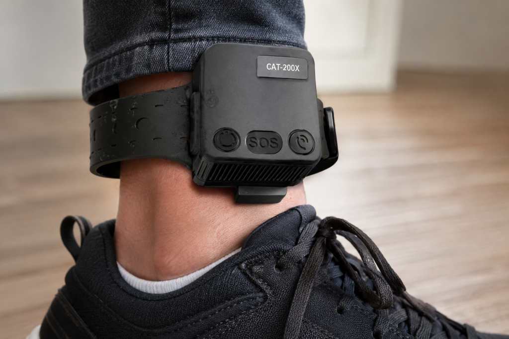
| Off-Site Suspect Monitoring | Signal jamming or unauthorized removal attempts | Waterproof ankle trackers with integrated belt-off security alarms |
Why Are Terrestrial Communications Insufficient for Police Operations?
Cellular communications fail during critical operations because consumer networks drop coverage in rural dead zones and congested urban centers. Dedicated hardware communicates directly with global satellite constellations, logging internal telemetry paths even when local mobile networks drop completely out of service during crisis situations.
Consumer cell phones perform adequately for standard urban communication, but they fail as emergency tactical lifelines. Active data tracking over standard cellular networks drains phone batteries within hours, leaving field agents isolated. Furthermore, typical commercial tracking apps do not offer the rugged enclosure ratings necessary to survive heavy rain, impact, or foot pursuits. When agencies select high-performance law enforcement GPS trackers from certified distributors, they gain situational awareness that transforms active pursuit operations.
Relying on terrestrial towers presents extreme risks during multi-jurisdictional investigations. If a target moves past a major ridge line or enters a subterranean parking garage, standard cellular pings vanish completely. Professional tracking setups rely on advanced satellite positioning systems like assisted GPS to maintain precise data streams across hostile terrain. This continuous stream provides commanders with the ground truth required to make rapid tactical decisions under pressure.
How Do Tactical Teams Deploy Covert Asset Trackers?
Tactical units deploy covert tracking hardware to follow high-value targets without initiating dangerous physical pursuits. These compact devices attach securely to suspect vehicles or high-risk cargo, transmitting location bursts via secure back-end servers to allow remote operators to monitor asset positions from any web browser.
Deploying modern law enforcement GPS trackers directly onto suspect vehicles eliminates the high-speed pursuit risks that endanger civilian lives. Specialized units use heavy-duty magnetic enclosures to place tracking hardware underneath target chassis in seconds. This allows undercover teams to maintain a safe distance while gathering continuous location intelligence.
Successful covert deployments depend on specific tactical methodologies to ensure long-term field success:
- Use motion-sensing power conservation protocols to ensure the device sleeps during extended stationary periods.
- Secure the tracker within an IP67 crushproof case to protect delicate internal components from road debris.
- Route private location data streams through multi-tenant cloud architectures to protect operational security.
- Deploy universal protocol hardware that integrates seamlessly with existing command center mapping applications.
By keeping physical tracking teams far out of sight, investigators reduce suspect suspicion. If a target believes they are unmonitored, they maintain standard behavioral patterns, leading teams directly to stash locations or accomplice hubs. This objective data trail provides prosecutors with undeniable timeline evidence when cases move to court.
What Hardware Features Protect Officers in High-Risk Zones?
High-risk tracking hardware protects field personnel by incorporating physical emergency alert buttons, high-frequency ping capabilities, and extended external battery architecture. These specific engineering attributes ensure that an officer can signal for immediate tactical assistance even if standard radio channels are jammed or compromised.
Commanders must balance hardware portability against operational lifespan when selecting field equipment. If a team enters a four-day tracking operation, a tool with a standard consumer battery will fail before the mission concludes. Many professional tracking setups allow agencies to connect heavy-duty external battery packs or tie devices directly into a vehicle electrical line for indefinite power.
Specialized law enforcement GPS trackers feature high-gain internal antennas capable of capturing satellite coordinates even when stuffed beneath heavy steel frames. This ensures continuous transmission when timing matters most.
Agencies optimize their tactical hardware arrays by evaluating these technical parameters:
- High-frequency polling adjustment that scales from thirty-second bursts during pursuits to hourly pings at camp.
- Integrated 3-axis accelerometers that instantly flag sudden impacts or unauthorized vehicle movement.
- Dual-antenna designs that automatically switch to the strongest available signal path in urban canyons.
- Dedicated SOS physical triggers that bypass standard menus to send immediate distress notifications to dispatchers.
Having immediate access to an automated distress trigger changes the safety dynamic for lone workers or undercover officers. If a meeting goes south, a single button press transmits exact coordinates to nearby backup units without requiring the officer to pull out a radio or look at a screen.
How Do Ankle Trackers Enhance Parole and Suspect Monitoring?
Bottom Line Up Front: Ankle tracking devices enhance suspect supervision by enforcing virtual geofences around restrictive zones. The underlying backend software continuously matches device coordinates against digital borders, firing automated text warnings to monitoring officers the exact second a subject crosses an authorized perimeter line.
Supervising individuals on conditional release requires absolute hardware reliability. Standard tracking protocols fail if a suspect can simply slip a device into a backpack and walk away. Professional ankle trackers utilize robust fiber-optic or steel-reinforced bands equipped with integrated belt-off alarms. If a subject attempts to cut or tamper with the strap, the device instantly transmits an emergency alert to the central office.
Deploying secure law enforcement GPS trackers into community supervision workflows protects public safety while minimizing administrative guesswork. Investigators use these automated perimeters to trace precise movements around victim residences, court boundaries, or high-crime municipal sectors. This digital perimeter guard operates twenty-four hours a day, keeping communities safer without requiring constant manual surveillance teams.
Frequently Asked Questions
Can commanders monitor field hardware from standard mobile devices?
Yes, modern asset tracking platforms provide full mobile compatibility via standard web browsers or dedicated applications. Command staff can view live positions, adjust active geofence shapes, and receive immediate distress text alerts directly on their personal phones while away from headquarters.
Do these tracking devices require a direct line of sight to function?
While an unobstructed view of the sky yields the highest possible precision, professional hardware utilizes advanced high-gain antennas and assisted GPS to maintain connection locks inside vehicles or under heavy tree canopy. If signals drop completely inside deep tunnels, internal memory chips store the coordinates until transmission returns.
How do tactical teams prevent moisture and dust damage during outdoor operations?
Teams utilize specialized heavy-duty waterproof housings or custom magnetic protective cases to shield internal circuits from extreme environmental exposure. These external accessories seal the tracking units against heavy rain, thick mud, and high-velocity road debris during extended field deployments.
Is it possible to use the same tracking platform for both vehicles and foot personnel?
Multi-purpose tracking hardware is engineered specifically to handle diverse operational parameters with complete flexibility. Operators can slip a compact portable tracker into a field agent’s gear pouch during a foot patrol, then connect that identical unit to a vehicle hardwire kit for asset tracking at night.
Secure Your Field Operations with Tracking the World
Managing complex group logistics in remote or high-risk environments does not have to be an unpredictable guessing game. Stop relying on weak cellular applications or irregular manual roll calls to keep your personnel safe. Reach out to the experienced technical team at Tracking the World to establish a highly reliable satellite safety infrastructure for your upcoming field operations. Explore our extensive array of professional-grade tracking systems or secure an engineered quote by calling our office directly at (650) 692-8100. You can also connect with our corporate technology specialists by emailing info@trackingtheworld.com to discover the exact hardware configuration tailored for your operational requirements.
![]()
The U.S. Air Force is set to receive a set of two A2100 composite satellite
structures and the first ship set of propellant tanks for the GPS III
satellites. These deliveries, which represent use of enhanced GPS tracking technology,
is only the first part in a much larger project in GPS tracking systems.
The GPS III structure is made from a composite material that is lightweight and
high-strength, which makes it ideal for integration into military hardware. The
GPS III satellites are expected to deliver navigation that is three times more
accurate than current GPS tracker systems in place. It will also have advanced anti-jam
capabilities, making it more predictable in hostile areas.
Good news for the rest of us, since the system will also be adding a new
international civil signal (L1C) that is designed to work with existing GPS tracking
systems. Just don’t expect to see results until after the project is completed in
2014.

Research at Ohio State University is providing more information on tracking underground nuclear tests from thousands of miles away through GPS tracking technology, as detailed in a presentation at the Comprehensive Nuclear-Test-Ban Treaty Organization meeting in Vienna.
Researchers hope the added use of GPS tracking technology, in addition seismic activity and chemical sensors already in use, will provide concrete evidence on underground nuclear tests, by pinpointing precisely when and where tests occur.
When a powerful underground nuclear test occurs, it creates changes in the Earth’s upper atmosphere, known as the ionisphere. The ionispheric changes are detectable by GPS tracking satellites, alerting scientists to the possibility of an underground nuclear test. The use of GPS tracking in this manner is still in development, with one of the biggest challenges being the ability to recognize the difference between an earthquake and an underground nuclear test.

